Under PMGSY-III, more than 7.70 lakh Rural Facilities have been Geo-Tagged
The Ministry of Rural Development is utilizing the Geographic Information System (GIS) for improvement in the planning and implementation of projects. GIS planning is being used for Mahatma Gandhi National Rural Employment Guarantee Scheme (MGNREGS) and Pradhan Mantri Gram Sadak Yojana (PMGSY).
Under PMGSY-III, more than 7.70 lakh rural facilities such as medical, educational and markets have been geo-tagged. Details of rural roads are available in the public domain at https://geosadak-pmgsy.nic.in/opendata. The GIS data created under PMGSY National GIS guideline is not just for rural areas but serves as a holistic national geospatial dataset including urban areas, National Highways, State Highways and Railway tracks, etc. GeoSadak has been developed utilizing fully indigenous GIS data layers and satellite data services.
Under Mahatma Gandhi NREGS, assets are created across the country related to water harvesting, drought relief, flood control activities, and sanitation. Satellite-derived Location-based services are being utilized for planning and monitoring nearly 7-8 million assets annually through the use of mobile-based geo-tagging. Online Geo-spatial maps are available at https://bhuvan-app2.nrsc.gov.in/mgnrega/mgnrega_phase2.php. A web GIS-based mechanism for creating geotags for all MGNREGA works across the country is very successful and presently 3 crore assets are geotagged.
Under MGNREGS, 2.56 lakh Gram Panchayats (GPs) have prepared the GIS-based GP plans as of 31st March 2022. Under PMGSY-III, 11537 numbers of sanctioned road proposals (87026.04 km length) have been drawn on the GIS (GeoSadak) platform.
To ensure better transparency in the implementation of the MGNREGS, mobile applications like Area Officers’ App and National Mobile Monitoring Software have been developed. The first one enables officers conducting inspections to record the findings of an inspection online. The latter enables taking attendance twice a day for every work which has a muster roll issued for more than 20 workers at a time. In all the above apps, geo-tagged time-stamped photographs are taken which are compared with the GIS coordinates of the site of the relevant work. Similar actions are taken at the time of inspecting PMGSY works.
Assets under Pradhan Mantri Awaas Yojana-Gramin and Shyama Prasad Mukherji Rurban Mission are also geo-tagged. In the former, 5 geotagged timestamped photographs are taken, to ensure that the scheme assistance is not misappropriated by diverting the funds elsewhere.
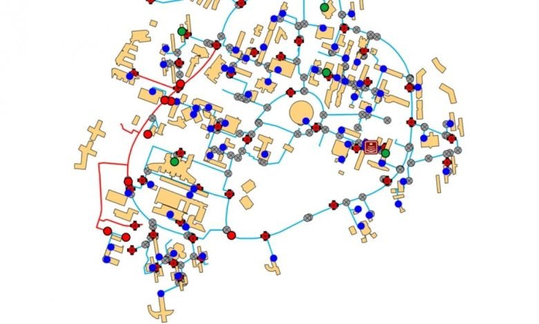
Under the PMGSY, the entire District Rural Road Plan (DRRP), Habitation and important socio-economic facilities have been geo-tagged on GIS and are being used for better planning and monitoring of projects. In PMGSY-III, National Rural Infrastructure Development Agency (NRIDA) has prepared a network planning algorithm called Trace Maps which simulates the traffic from habitations to nearby facilities to identify and calculate road usage in rural areas.
This information is then used to suggest important routes and major rural links to field engineers help them with planning. Further, road proposals proposed by states are also scrutinized on a sample basis on GIS along with satellite imagery and other informative layers to see if the roads are meeting PMGSY-III objectives. NRIDA has prepared a Web GIS tool called GeoSADAK which allows for NRIDA, State Rural Road Development Agency (SRRDA) and PIUs to make use of GIS without needing specialized GIS expertise. Programme Implementation Unit can draw the proposals on the tool under their login and SRRDA and NRIDA can verify the alignments before sanction.
This information was given by the Union Minister of State for Rural Development Sadhvi Niranjan Jyoti in a written reply in Rajya Sabha today.